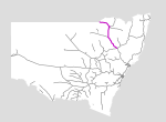
Mungindi Line
Summary
| Track: | 378.67 km |
| Stations: | 6 / 23 in use |
The Mungindi branch starts at the major rail centre of Werris Creek, and heads north to the remote town of Mungindi, on the Queensland border. Along the line are the major towns of Narrabri and Moree.
Today it is utilised for almost its entire length for grain transport, and for coal from the Preston and Gunnedah collieries. Only the final 27km is out of use, having been so since floodwaters damaged the line in 1974.
| Name | Facility | Status | Opened | Closed | km | Links | ||
|
|
Werris Creek | Station | In Use | 14-Oct-1878 | - | 410.700 | 26 | |
|
|
Jct (Gap) | Junction | In Use | unknown | - | 1 | ||
|
|
Gap | Platform | Closed | 20-Jun-1940 | 17-Sep-1971 | 416.050 | 7 | |
|
|
Burilda | Loop | Closed | 18-Jun-1908 | unknown | 422.360 | 2 | |
|
|
Breeza Tank | Tank | Closed | 25-Mar-1879 | unknown | 432.241 | ||
|
|
Breeza | Unknown | Unknown | 24-Mar-1879 | 433.900 | 2 | ||
|
|
Watermark | Loop | Closed | 12-Oct-1911 | unknown | 445.600 | 3 | |
|
|
Nea | Unknown | Closed | 1911 | 26-Feb-1966 | 449.957 | 3 | |
|
|
Curlewis | Station | Closed | 1909 | unknown | 458.500 | 10 | |
|
|
Gunnedah | Station | In Use | 11-Sep-1879 | - | 475.800 | 11 | |
|
|
Gunnedah West | Station | Closed | 26-Oct-1925 | 6-May-1955 | 481.657 | 4 | |
|
|
Emerald Hill | Station | Unknown | 1883 | 493.400 | 11 | ||
|
|
Dubbleda | Loop | Closed | 13-Oct-1911 | 5-Jun-1917 | 504.026 | ||
|
|
Boggabri | Station | In Use | 11-Jul-1882 | - | 515.170 | 6 | |
|
|
Boggabri Coal Loop | Other | In Use | 29-Oct-2006 | - | 521.402 | 3 | |
|
|
Baan Baa | Station | Unknown | 1883 | 530.700 | 1 | ||
|
|
Turrawan | Station | Closed | 1884 | unknown | 547.600 | 1 | |
|
|
Tibberena | Unknown | Closed | 30-Oct-1909 | 27-Feb-1955 | 561.979 | ||
|
|
Narrabri South Junction | Junction | In Use | unknown | - | 565.009 | ||
|
|
Narrabri Junction Platform | Platform | Unknown | unknown | 565.000 | 5 | ||
|
|
Narrabri North Junction | Junction | In Use | unknown | - | 1 | ||
|
|
Narrabri | Station | In Use | 1-Apr-1897 | - | 569.200 | 8 | |
|
|
Edgeroi | Station | Closed | 1-Apr-1897 | unknown | 593.600 | 7 | |
|
|
Woolenget | Unknown | Closed | 9-Sep-1901 | 18-Jul-1951 | 596.864 | ||
|
|
Bellata | Station | In Use | 1-Apr-1897 | unknown | 615.460 | 5 | |
|
|
Kilgowla | Unknown | Closed | 12-May-1906 | 27-Jul-1974 | 627.913 | ||
|
|
Gurley | Station | Closed | 1-Apr-1897 | unknown | 635.400 | 3 | |
|
|
Tycannah | Unknown | Closed | 1-Apr-1897 | 27-Jul-1974 | 649.232 | ||
|
|
Moree | Station | In Use | 1-Apr-1897 | - | 665.600 | 14 | |
|
|
Camurra | Station | Closed | 29-Sep-1913 | unknown | 676.904 | 2 | |
|
|
Ashley | Station | Closed | 29-Sep-1913 | 17-Dec-1974 | 692.252 | ||
|
|
Moppin | Station | Closed | 29-Sep-1913 | 20-Feb-1975 | 705.622 | ||
|
|
Garah | Station | Closed | 29-Sep-1913 | 17-Mar-1974 | 724.100 | 5 | |
|
|
Bengerang | Station | Closed | 29-Sep-1913 | 20-Feb-1975 | 741.802 | ||
|
|
Weemelah | Station | Closed | 7-Dec-1914 | unknown | 762.500 | 5 | |
|
|
Neeworra | Station | Closed | 7-Dec-1914 | 20-Feb-1975 | 779.293 | ||
|
|
Mungindi | Station | Closed | 7-Dec-1914 | unknown | 789.370 | 6 |
Summary
| Track: | 378.67 km |
| Stations: | 6 / 23 in use |
| Section | Opened | Closed | Usage | ||
| Werris Creek - Breeza | 25-Mar-1879 | general | |||
| Breeza - Gunnedah | 11-Sep-1879 | general | |||
| Gunnedah - Boggabri | 11-Jul-1882 | general | |||
| Boggabri - Narrabri South Junction | 1-Oct-1882 | general | |||
| Narrabri South Junction - Moree | 1-Apr-1897 | general | |||
| Moree - Garah | 29-Sep-1913 | general | |||
| Garah - Weemelah | 7-Dec-1914 | general | |||
| Weemelah - Mungindi | 7-Dec-1914 | 11-Jan-1974 | general |